ETEC 647: Emerging Technologies for Learing (Dr. Bert Kimura, Spring 2012)
DESCRIPTION
Our group developed an assignment that was used by the class on how can you use Google Maps to map out an evacuation route to safety. It also discussed how to upload your evacuation route and accompanying pictures to a shared Google Map, and share your route with a social media tool.
REFLECTION
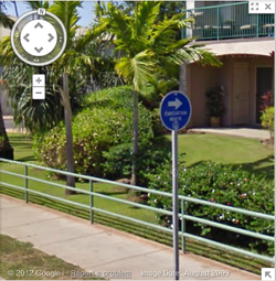 Evacuation route sign along South Kihei Road.
We chose Davilla's apartment as our site. She is located within the tsunami evacuation zone in South Kihei, Maui. During the past two tsunami warnings, she had to evacuate out of the zone. Both times, police cars with full lights, went up and down her street announcing that everyone was mandated to evacuate by a certain time.
From doing a walk through in Google Maps street view, I saw an evacuation route sign along South Kihei Road (see pic). It wasn’t specific to a tsunami evacuation, but was a similar path as well. I learned that it’s important to have an evacuation route plan and that the entire family knows and practices the route. It’s best to be prepared before something happens. Seeing actual pictures of the route help to create a vivid picture of where you are going, rather than just points and names.
This is a very relevant and practical assignment for someone living in a tsunami evacuation route. The geolocation of pictures onto the map with the evacuation route overlay would have been a nice synergy. Perhaps an option could be made for members that do no live in a tsunami evacuation area that involves integration of google maps, and social networks.
AECT STANDARDS
|
Standard 1: Content Knowledge
Candidates demonstrate the knowledge necessary to create, use, assess, and manage theoretical and practical applications of educational technologies and processes. |
Standard 2: Content Pedagogy
Candidates develop as reflective practitioners able to demonstrate effective implementation of educational technologies and processes based on contemporary content and pedagogy. |
Standard 3: Learning Environments
Candidates facilitate learning by creating, using, evaluating, and managing effective learning environments. |
Standard 4: Professional Knowledge and Skills
Candidates design, develop, implement, and evaluate technology-rich learning environments within a supportive community of practice. |
FEEDBACK
|
RATING
4
5
4
5
|
COMMENTS
Hello Team Kihei,
Your Google Map of the Tsunami Evacuation Route was a great one! It was very helpful especially because your provided about 10 pictures to show the actual view of the route you chose. I wasn't able to find a link to your social media postings you listed (Twitter & LinkedIn) but I was able to view the photo album link. I like how you provided the photos in the Google+ photo album as an alternative to the Google Map. The reflection statement did give evidence of your group's learning and I believe your group met the objectives of this project. I think you chose a good evacuation route considering Davilla has actually been forced to evacuate due to a tsunami warning. You also provided good feedback on how the assignment could be improved. I agree, an option for members that do no live in a tsunami evacuation area that involves integration of google maps, and social networks would be a good idea to improve this assignment and make it a little more relevant for everyone in the group. Great Job Team Kihei. Hi Team Kihei!
You have a great Google map of your evacuation route with accompanying photos and descriptions. I also see your map and photos posted on Google+. Your reflection indicates clear learning of the objectives. Like your team, not everyone on our team lived in an evacuation zone and your suggestion for modifying the assignment seems logical. Out of curiosity, did Davilla use this or a similar route during any of the two evacuations she experienced? If so, how did it work out? Does she meet up with neighbors as a way to support each other? Thanks! I heard: I saw that the group chose to use an evacuation route that Davilla had to use twice during the last two tsunami warnings. I am familiar with Davilla’s location which made it easier for me to understand. Kihei is a low lying community so having an evacuation plan is critical for those who live in that area.
I noticed: I noticed the pictures that were used in the evacuation plan are from Google Maps. This brings familiarity for those who want to practice the route on their own. I like the fact that there was a picture of the evacuation route sign. These signs can give direction to the tourists and locals alike on where to go. There should be more signs like those leading to tsunami evacuation sites. I wondered: Being Kihei is a tourist destination, I would think adding an evacuation site would help for those not familiar with the area and have no friends close by to evacuate to. Also, there was no mention of any other options for evacuation. Maybe having a statement of why this particular route was chosen over another could clarify if there are other options. I would like to have links to the social media post. Good job!
I thought it was so cool that you were able to see a sign using the Google street view. That's something that wasn't possible a generation ago. It makes me wonder what kind of additional information we could gain in the future as technology continues to develop. I have heard apple might start utilizing a new mapping technology as they have already bought out multiple mapping technologies. I also read how microsoft bings maps, already have some advantages over google maps. Hearing of davilla's experiences with evacuation, makes the assignment feel so much more real. I haven't had to evacuate my home before, but that doesn't mean that tsunami evacuations shouldn't be taken serious. |
